
I admit to being an old fogey….but paper maps are still the best. You can have your guidebooks and maps on your phone or on your e-reader. But nothing is better than your paper map…. and they don’t need a battery.
Endless hours have been spent researching which guidebooks and maps to use and seeking out free maps. I’ve reached a point where I am now generally happy with my selection.
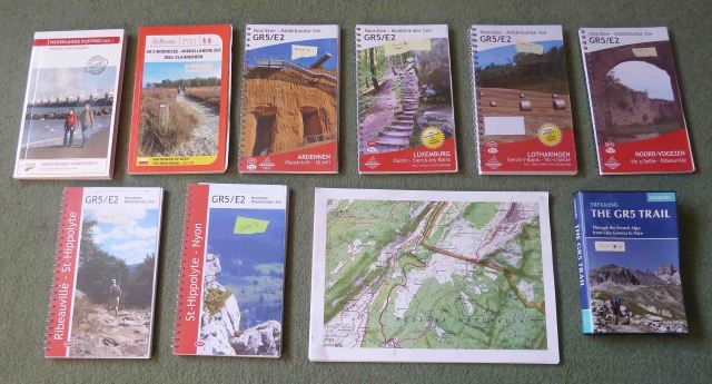
The de-facto standard for any GR (Grande Randonnee) route are the French TopoGuides. My research led me to believe they have some problems with this route….reports of out-of-date information, and some sections for which I couldn’t even find available guides in print. I have used TopoGuides before (a long time ago) and found them quite hard to use due to excessive contours – a steep slope is shown with so many contours it looks like a cliff and the contours obscured all other detail. Perhaps things have improved, perhaps not.
My searches led me to “De Wandelende Cartograaf” – the [Dutch] Wandering Cartographer and his guides. These are recent guides. The final one – Book 3 in my list – only came out about 2 months ago. An obvious disadvantage (for me) is the language since they are written in Dutch, but they do what is needed. They have a large scale map, show shops and show campsites. These guides cover the route from Belgium to Lake Geneva in a series of 7 guides (books 2 to 8 in the photo above).

As with all guides these aren’t perfect – they are basically good printouts of Open Street Map (OSM) maps. Viewed as such they are very pricey, but still they cost less than printing them out yourself. They don’t have contours, but they do have section summaries with elevation plots, which are good enough for the areas they cover. I wouldn’t want them as my only resource in a mountain section though.
The first stage, in the Netherlands, from Hoek-van-Holland to Bergen-op-Zoom is covered by a different guide. This is from Wandelnet, “Wandelgids 5-1 LAW Nederlands Kustpad deel 1” (book 1 in the photo above). It is of a similar standard to the Dutch guides above, but is not written around the GR5 – you will find yourself flicking backwards and forwards through the book to find your route. Having bought it, I concluded it was best to copy the relevant pages and then put them in GR5 order. I won’t be carrying the book with me. If I hadn’t already bought it, my recommendation would be to print off your own maps from OpenStreetMap using the ‘JGN’ resource below.
The books (1 to 8) are not readily available in the UK. I bought them all from de Zwerver bookshop (Groningen , Netherlands) – just type ‘GR5’ in their search box. Very good service and cheap postage.
So we now have our maps from Hoek-van-Holland to Lake Geneva.
The next stage is the route around Lake Geneva. The GR5 route takes the ferry across the lake. My rules don’t allow this! So I need a route around the west of Geneva. I started working out my own route, before stumbling across the GR Balcon du Leman, which does exactly what I want! I couldn’t find a guide for this, but it is marked on the French IGN topo maps. The IGN allow you to download and print their maps (see the IGN Geoportail). However…it didn’t work very well for me. The printouts had a small map area in a large border that I failed to be able to change.
More searching led me to another site. JGN.superheros.fr

This site makes selection and printing A4 images easy. And has the added bonus of not only printing IGN maps, but also many others, such as OpenStreetMap, OpenCycleMap and various Google maps.
Now we’ve got to the south of Lake Geneva. The final (and most interesting stage) is over the Alps.
A single guidebook is available to cover this stage. The Cicerone guide is comprehensive Cicerone GR5 Guide, although as normal with Paddy Dillon’s guides I find the timings a bit (very!) optimistic for my old body. Although you could probably manage with the guide alone since the GR5 is well marked, I would always take a topo map. So it was back to JGN to print the maps. This was a big task – it is a lot of miles across the Alps. I then found someone has already done it all for me, and bundled all the maps into a big PDF file that can be downloaded. And they include both routes from St Dalmas – the GR52 to Menton (my route) and the GR5 to Nice. Thanks go to Made-In-England for some fine work here.
Phew! We got there in the end. A full set of maps.
