
Why? Because it’s not the Appalachian Trail.
The original plan was to have a go at the Appalachian Trail (AT) after having done 1300 miles on the Pacific Crest Trail (PCT) a couple of years ago.
Long distance hiking gets in your blood – especially after spending time on the magnificent PCT. I was thwarted on the PCT by the insect life that became unbearable after several days of torment, so began looking at other hikes this time. As the most famous of the long distance trails the AT was an obvious choice.
But having made the decision to go on a hike, the more I looked at the AT and hikers’ stories, the less appealing it looked. Seems to have the same (or worse) insect life, and a LOT of rain – tales of 15 continuous days where it rained were not uncommon. If I want that I’ll go to Scotland.
Looking elsewhere, other possible trials (or trails) were considered and rejected….
- Te Araroa traversing New Zealand – similar problems with insects (sand flies apparently) and rain
- Continental Divide Trail (CDT) – a bit too similar to the PCT, but harder!
- England’s South West Coast Path – too short and too touristy
- E12 along Spain, France and Italy coast – have already done parts of this.
The E2 (European Route 2), starts in Ireland, crosses into Scotland, goes down England then across the channel and down through mainland Europe to the Mediterranean.
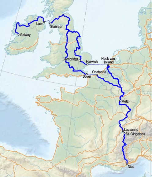
The whole E2 is too long for the time I have available, and involves ferries – which are not allowed on my hikes. If it is not a continuous walk it doesn’t make the cut.
However, the mainland European section – which is the Grand Randonee Route 5 (GR5) – ticked a lot of boxes.
- It is continuous (well mostly). It uses a ferry across Lake Geneva, but I worked out a hiking route around the lake that avoids the ferry. OK it is a 90 mile detour, but rules are rules! No ferries allowed.
- It is a sensible distance. It will top out at around 1500 miles with my detour.
- The climate should be OK. Starting May, finishing end of July. That said, it has been a big snow year this year. I expect there will still be snow on some of the passes in the Alps in late June/early July. My hiking spikes will have to be taken.
- Has a good variety of scenery from the pan-flat Netherlands to the very pointy Alps.
- Has definite start and end points – starts at the sea, ends at the sea.
The choice of starting point was really down to convenience of train routes to the English port and ferry timetable across the Channel. I have chosen the northern start (Hoek-van-Holland).
